


Projects
23.06.23
Helsinki

Linking survey results with geospatial data can be extremely useful to a city, providing additional information and insight beyond traditional surveys.
Billboard
Skyscrapper
Halfpage
Maptionnaire is a citizen engagement platform that provides planners with tools for collecting data with surveys, analysing results in GIS format, and communicating about city development projects. Maptionnaire users can create custom webpages, surveys, and interactive maps that are linked to geospatial data widely used in urban planning, environmental management, and city development.
Linking survey results with geospatial data can be extremely useful to a city. It can provide additional information and insight beyond traditional surveys. There are numerous examples of how this linkage can provide useful information to a city government. For example, through spatial analysis. By assigning survey responses to specific locations, patterns and trends can be revealed that are geographically determined. For instance, information about how people rate certain services or what problems occur in different neighborhoods could be analyzed spatially. This allows cities to take targeted action and allocate resources more effectively.
Better understanding of the community
Urban planning can benefit from citizen participation through geo-linked surveys. Using Maptionnaire, cities can conduct citizen surveys and gather feedback on urban development projects, transportation planning, park design, and more. Simultaneous linking with geospatial data allows citizens to express their opinions and ideas based on locations on a clear map. This allows the city to better understand community preferences and needs.
In a city’s environmental management, combining survey results with geospatial data can help evaluate and improve environmental aspects in a city. For example, citizens could ask for feedback on green initiatives, recycling programs, or the quality of green spaces. By spatially analyzing this information, the city can identify environmental issues and take targeted action to address them.
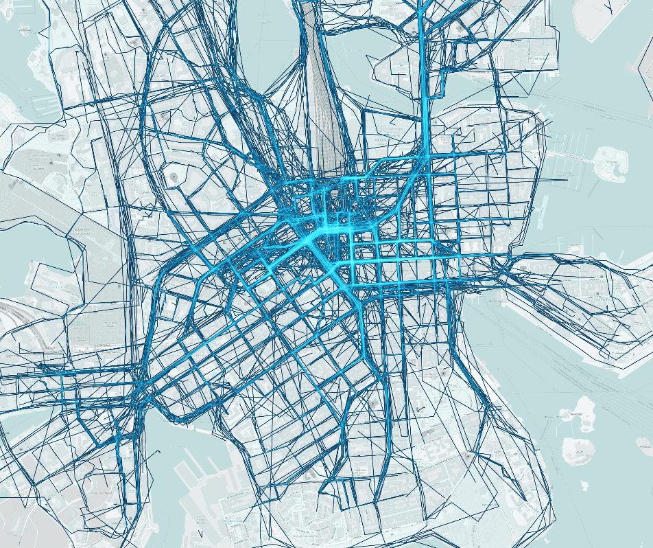
With Maptionnaire, survey results can be easily visualized in heatmaps. This example shows everyday Routes of Helsinki citizens. Graphic: Maptionnaire
Tools such as Maptionnaire can also be helpful in acute situations. In the event of natural disasters, epidemics, or other crisis situations, surveys can be used in conjunction with geospatial data to gather information about affected areas, the needs of the population, or the effectiveness of emergency measures. This enables authorities to deploy resources efficiently and respond quickly to community needs.
Maptionnaire and Helsinki
In Helsinki, several exciting projects have already been supported and successfully implemented with the help of Maptionnaire. The goals of these projects have been not only to improve urban mobility and better understand the needs of residents in terms of traffic and transportation. It was also to identify areas within the city where there is more or less need for development. As part of the various projects, Helsinki residents were invited to share their experiences. Ideas and suggestions for improving the living situation in the city were collected using Maptionnaire. The platform offered them the opportunity to rate places, routes and transport connections marked on a map or to leave comments and suggestions about specific places and topics in the city.
The collected data was then evaluated and analyzed by the project teams. They served as an important basis for planning and implementing measures to improve urban mobility in Helsinki, for example. The project team worked closely with local authorities, participating companies, service providers and urban planners to take into account citizens’ priorities and develop innovative solutions.
Based on the findings of the Maptionnaire surveys, various measures could be taken. These include optimizing traffic routes, improving pedestrian and bicycle infrastructure. Expanding the public transport network and creating new mobility services were other important steps. The measures helped to increase the quality of life of residents, improve transport efficiency and reduce the environmental impact of transport.
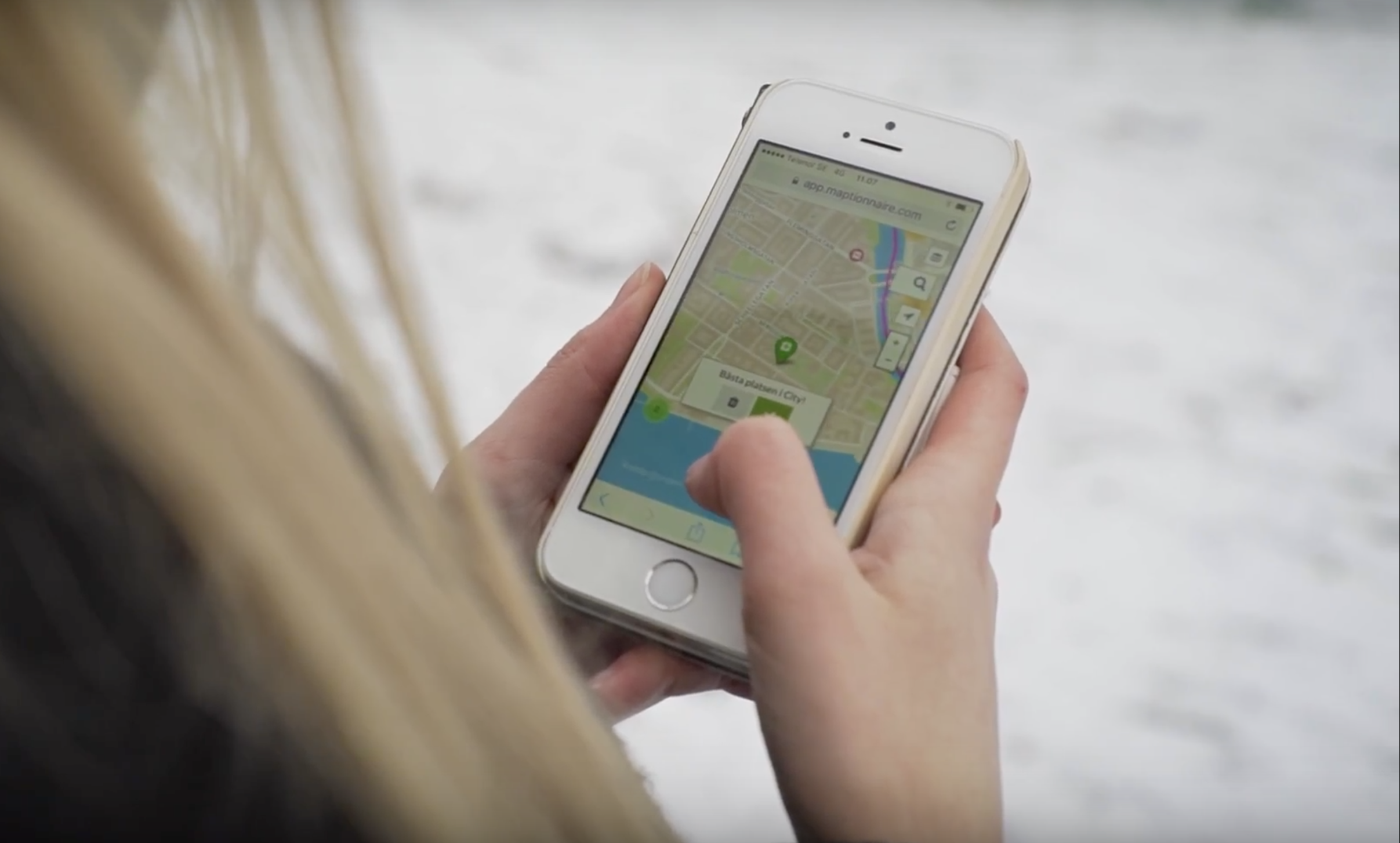
Residents can conveniently participate in Maptionnaire surveys via any mobile device with internet connection without downloading any apps. Photo: Maptionnaire
Walkability in the Finnish Capital
One of the projects carried out in the city with the help of Maptionnaire was the Helsinki Walkability Project. It surveyed the current state of pedestrian traffic and potential areas for development. Not only residents of the city, but also visitors could participate in the survey. It consisted of marking on a map commonly used routes that were perceived as problematic. After tracing the route, respondents could choose from a selection of reasons why they chose that route, and more than one reason could be given.
Unsurprisingly, for non-recreational walking routes, speed of route, practicality and ease of use were the most important characteristics for users. Less important, on the other hand, were characteristics such as the greenness of the route, or whether there were interesting places along the way.
The situation was different for recreational trail routes, i.e. routes related to outdoor activities or recreation. A particularly high density of these routes occurred around Lake Töölönlathi, the coastal areas, Esplanadi Park, and the Central Station, for example. In contrast to the utility routes, it became clear that here the convenience of the route and the attractiveness of the environment through which it passes are the decisive factors.
At a Glance
Thanks to the linking of the collected data with geodata, it became clear at a glance where the places are where things are going particularly badly or particularly well. Equally valuable was the option of asking respondents for free-text answers. This resulted in concrete wishes from the citizens for their city. Among them were reduction in car traffic, better consideration and prioritization of pedestrians in city traffic. One creative suggestion – and here the typical Finnish weather probably tipped the scales – was to consider the possibility of covering distances in the city in interior spaces.
Since its foundation in 2011, Maptionnaire has generated more than 25 million survey responses. It supported more than 13,000 projects around the world with the resulting data. To find out more about them, visit their website: maptionnaire.com
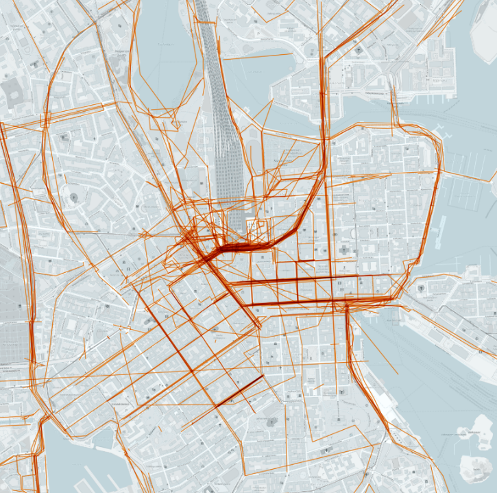
This heat map shows routes in Helsinki that survey respondents believe need improvement. Graphic: Maptionnaire
Medium Rectangle
Halfpage


Billboard
Other Articles you may like


