


Ideas
01.03.23
Ideas
MVRDV: Possible urban planning solutions for sea level rise
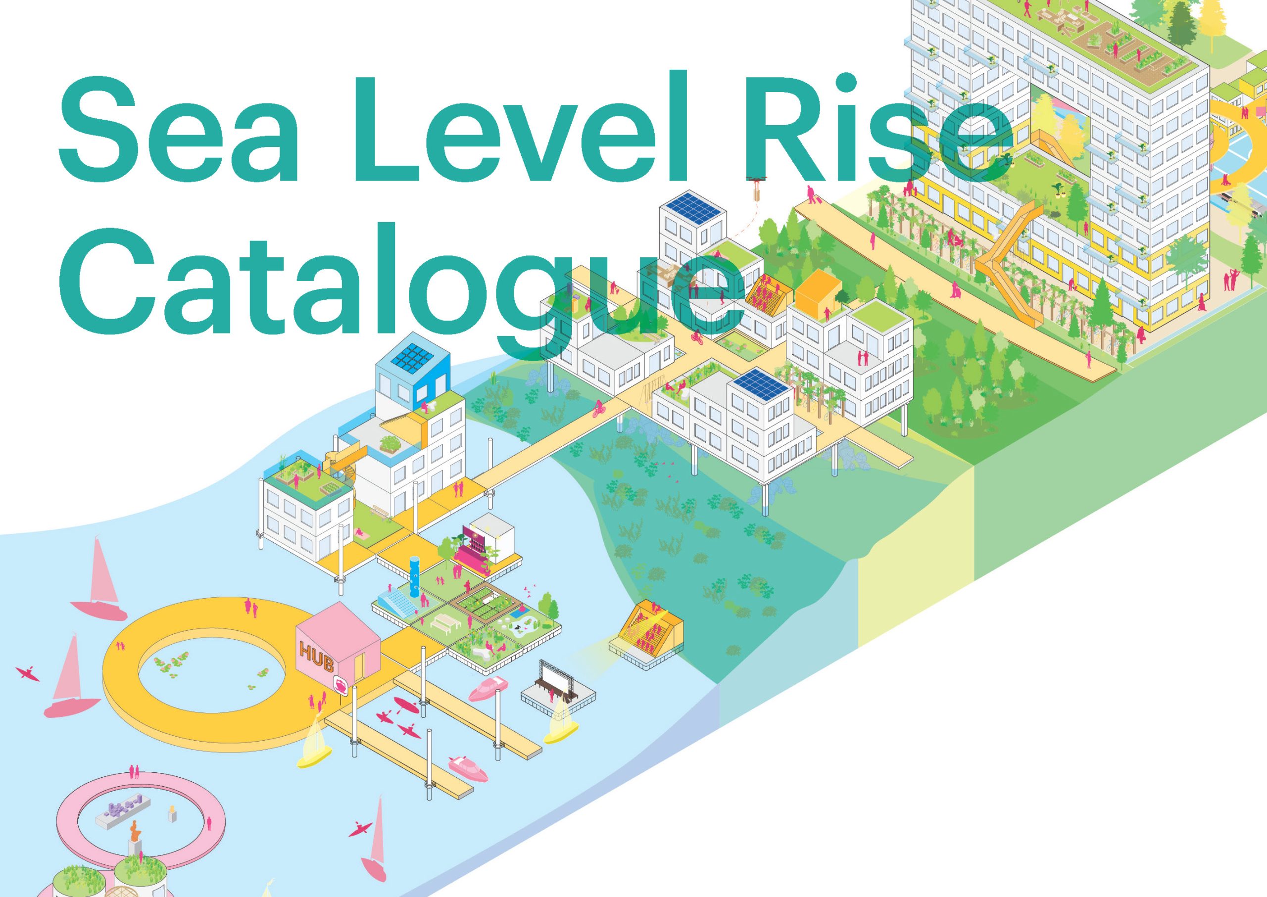
Sea Level Rise Catalogue. Image: MVRDV
Billboard
Skyscrapper
Halfpage
MVRDV has published a study that offers possible solutions for urban planning to deal with the problems of rising sea levels. MVRDV’s project example: Vancouver’s waterfront. Read more here.
The Sea Level Rise Catalogue
Dutch architecture studio MVRDV has released a study aiming to offer solutions to urban planning in the face of rising sea levels. This study centres on reimagining the Vancouver waterfront, which needs new methods for adapting to rising sea levels. As part of Vancouver’s Sea2City Challenge, the resulting Sea Level Rise Catalogue of the study provides new ideas for adaptation solutions.
According to the IPCC, sea levels could rise as much as two metres by 2100, creating many problems for the countless large cities located along the world’s coasts. In the report, MVRDV says that “there is time to develop and implement this change if we start now”, since sea level rise is gradual. The architecture studio also stresses that “cities need to leverage this urgency to develop and test adaptation solutions”. In addition, sharing knowledge will support coastal communities towards a more sustainable future.
MVRDV calls for new, more innovative approaches to protecting waterfront areas. It also asks readers to use a more nature-based language when talking about infrastructure related to climate change. “Protecting”, “hosting”, and “restoring” are example terms, which according to MVRDV are the opposites of “nature-detached” terms in use today.
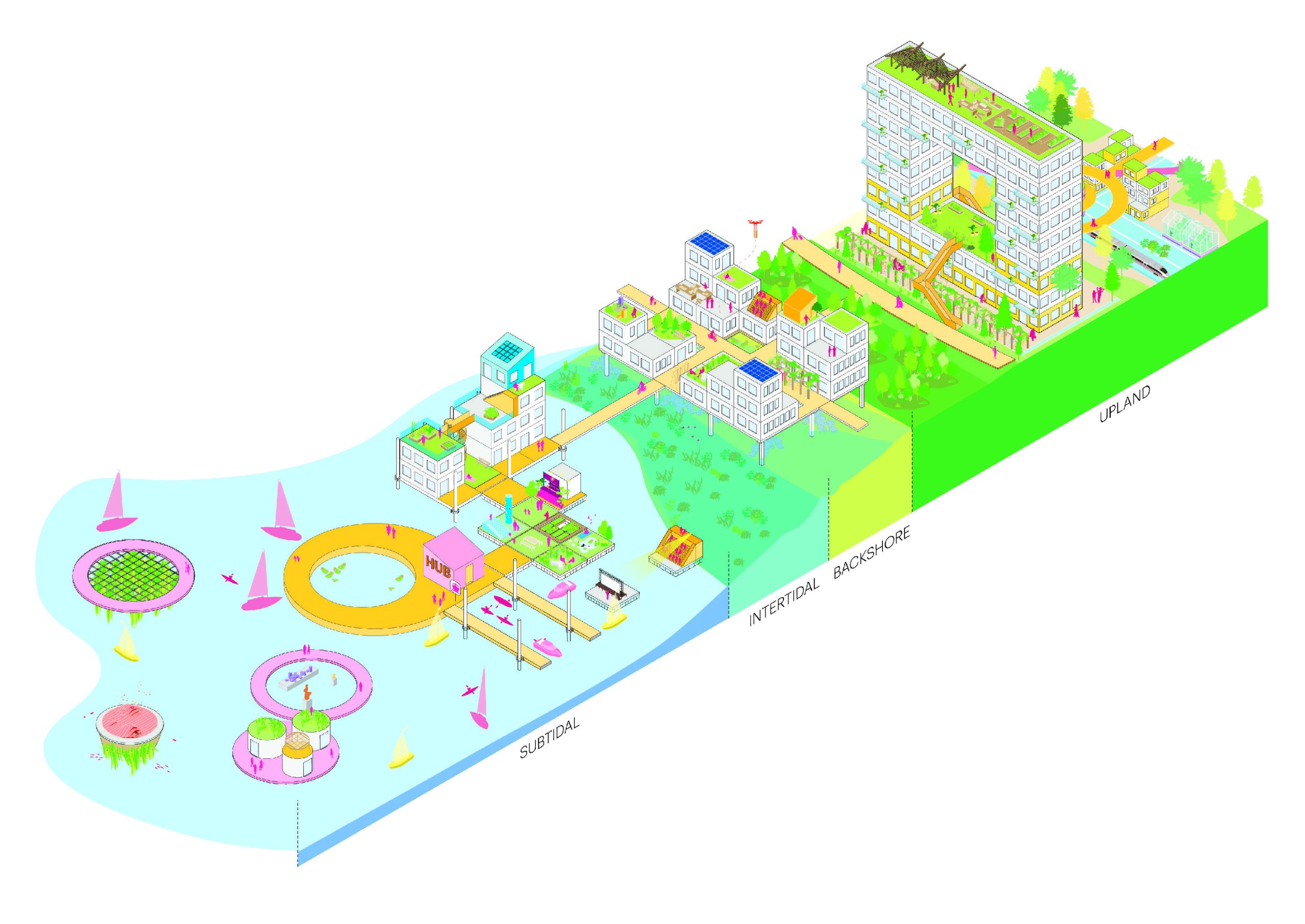
MVRDV's report includes many solutions for sea level adaptation. Image: MVRDV
Adaptation solutions
Some of the solutions that MVRDV suggests include stilts, upgraded utilities, construction of buildings on top of water, and tearing down certain buildings. They range from adapting pre-existing structures to upgrades and new constructions. Importantly, adapting to sea level rise will look differently in each city. A certain combination of retreat, protect, and adapt will work in any circumstances. Sometimes, even moving towards the water can be useful.
The pilot projects described in the study are for immediate use. Vancouver is the main test case in MVRDV’s document. Here, the design studio reimagines the waterfront along False Creek, calling for a more resilient architecture. Working closely with the city has resulted in a vision for the next 100 years of the city that could inspire other, similarly located cities.
The “rewilding” principle is key in the case of Vancouver. This means the restoration of land to its natural uncultivated state and reintroducing wild animals. Looking to nature and to history is key. MVRDV has placed great importance on community inclusion for its Vancouver proposal. By consulting with local groups and especially with advisors from the local First Nations, a different relationship between the city and the waterfront might be possible.
Medium Rectangle
Halfpage


Vancouver's False Creek could look like this in 2040. Image: MVRDV

Visualisation of False Creek in 2100. Image: MVRDV
A new waterfront for Vancouver
MVRDV proposes a new waterfront for Vancouver by 2100 in its studies. The current dykes and walls blocking the water level will no longer be viable by then. Using the principles of its Sea Level Rise Catalogue, MVRDV has developed a series of pilot structures for the subtidal zone of Vancouver’s False Creek. They include a floating island that would serve as a refuge for animals. From there towards the shore, there would be a floating pavilion accessible via kayak. It could hold a water-monitoring station and provide access to the city.
The current seawall, which in the future will be submerged more frequently, would host the pavilion. It would also act as a community and cultural centre. A forested area will act as a buffer between the pavilion and the existing infrastructure, according to the proposal. A series of walkways on top of the water would maintain connections.
This new waterfront for Vancouver would be gradually constructed until the year 2100. It will increase the land known as the “backshore”, the land between high and low tide, to better accommodate floods and extreme weather events. These are the six fundamental principles of MVRDV:
- Upgrading utilities and elevating some of them away from the water
- Finding new, flood-proof uses for underground structures
- Lifting the ground floor of buildings
- Developing raised walkways to connect structures
- Rearranging buildings’ programmes and making them more flexible
- Adapting structures to enable changes in use, and designing new structures to be more easily adapted
Medium Rectangle
Halfpage

Visualisation of Cooper's Park in 2040. Image: MVRDV

Cooper's Park by the year 2100. Image: MVRDV
The Sea2City initiative
Vancouver has launched the Sea2City initiative to bring together various architecture studios to work alongside the local community and the government. The suggested projects will not be built immediately, but they will form part of a framework and vision to guide urban development and ecological revitalisation in False Creek.
Importantly, the Sea2City initiative recognised that common approaches to urban waterfronts, such as resisting the water with hard infrastructure, are no longer effective. In an era of rising sea levels and more frequent extreme weather events, architects place more focus on allowing cities to coexist with the water.
The city of Vancouver is situated on the unceded traditional homelands of the Musqueam, the Squamish, and the Tsleil-Waututh First Nations. The False Creek area is of significant meaning to the First Nations. They have stewarded the land since time immemorial and have played an important role in advising on the future of the flood-vulnerable shoreline.
The collaborative design challenge ran over a 12-month-period. Its next phase will be the development of a Climate Adaptation Plan and a Coastal Adaptation Plan.
Read more: topos 87 focused on coastal strategies.
Medium Rectangle
Halfpage
Billboard
Other Articles you may like


