Addressing the climate crisis and public health emergency from an urbanistic point of view: The project Air/Aria/Aire and the case of Barcelona.
Billboard
Skyscrapper
Halfpage
When it comes to air pollution, cities are fighting a permanent pandemic. In light of the magnitude of the problem, Barcelona architect and curator Olga Subirós recognised the urgency of addressing the climate crisis and public health emergency from an urbanistic point of view. Using Barcelona as a case study, the project Air/Aria/Aire analyses data sets to showcase the impact of air pollution from the urban scale down to the street level. An exhibition about Air/Aria/Aire, curated by Olga Subirós, will be presented at the International Architecture Exhibition 2021 in Venice, exploring the notion of air as a common good that is vital to people’s health and striving to respond to the Biennale’s theme of ‘How will we live together?’ – an even more vital question in times of coronavirus.
Air pollution is the second leading cause of death from non-communicable diseases after tobacco smoking, according to the WHO. Worldwide, nine out of ten people breathe air that exceeds the safe limits set by the WHO guidelines. Last year’s EU report on air quality in Europe stated that air pollution “…is currently the most important environmental risk to human health”. In Europe alone, an estimated 400,000 people die every year from exposure to fine particulate matter in polluted air.
Medium Rectangle
Halfpage
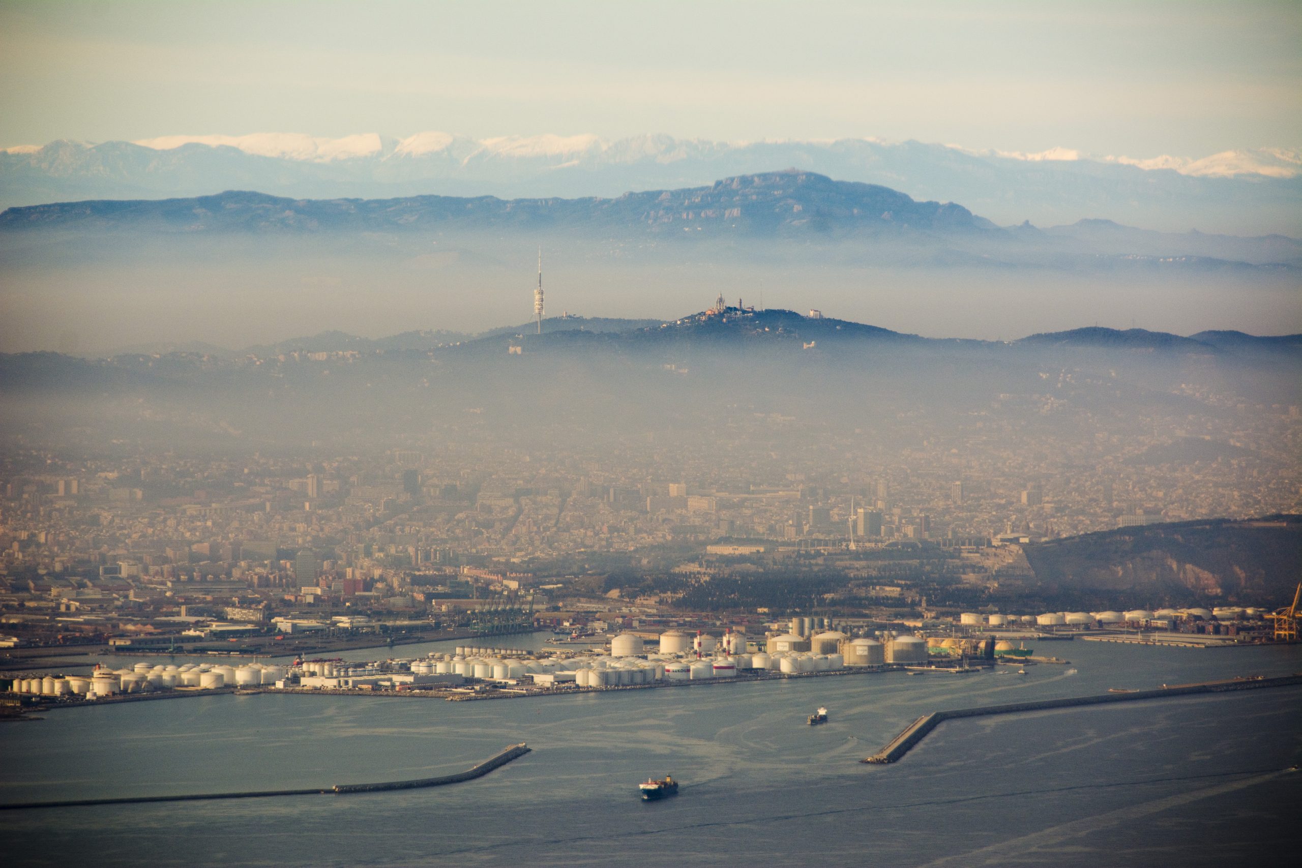
BARCELONA HAS THE HIGHEST VEHICLE DENSITY IN EUROPE. AROUND 500,000 CARS ENTER AND LEAVE THE CITY EVERY DAY. STREETS AND PARKING LOTS OCCUPY 60 PER CENT OF PUBLIC SPACE. © GUNNAR KNECHTEL
Billboard
Air as a common good
In light of the magnitude of the problem, Barcelona architect and curator Olga Subirós recognised the urgency of addressing the climate crisis and public health emergency from an urbanistic point of view. Noticing the absence of any major exhibitions with a focus on these issues at the previous Venice Architecture Biennale in 2018 she decided to enter the competition to represent Catalonia in Venice in the latest edition, curated by Hashim Sarkis, which has now been postponed until 2021. A unique interpretation of the Biennale’s theme “How will we live together?”, Air/Aria/Aire acknowledges and explores the notion of air as a common good that is vital not only to live but to survive together. The spotlight has been shifted from the built environment to the void that surrounds it, a space often neglected by architects.
Urban analytics and data curation to examine complex environments
Using Barcelona as a case study, Air/Aria/Aire meticulously analyses large data sets in order to showcase the impact air pollution has on the city, from the urban scale down to street level. With 6000 cars/km2, Barcelona has the highest vehicle density in Europe. Around 500,000 cars enter and leave the city every day. Streets and parking lots occupy 60 per cent of public space. Like Madrid, the city consistently breaches EU rules on nitrogen dioxide values and has been referred to the Court of Justice because of poor air quality. To map the city for Air/Aria/Aire, Olga Subirós teamed up with the award-winning local firm 300.000 Km/s, an architecture studio specialising in the use of digital technologies to harness open data and citizen-generated data. With projects such as their Land Use Plan for Barcelona’s old city centre, they reinvented the traditional master plan with new methodologies of spatial analysis. According to the firm’s directors Mar Santamaria and Pablo Martínez, “The city will belong to those who map it”.
Citizen participation is crucial
Traditional urban planning tools are no longer adequate for investigating and describing the complexity of our fast-changing urban landscapes. “This is why studying the city using big data and the models derived from it is invaluable to improving knowledge and, most of all, empowering citizens and allowing people to make collective decisions about their urban environments.” Data sets from the European Space Agency and weather stations as well as models established by Catalan research groups, such as an air pollution simulation by the Barcelona Super-computing Centre, Lobelia Earth’s predictive air pollution model and health impact studies by ISGlobal and the Barcelona City Council’s Public Health Agency were all used to produce the maps. Big data doesn’t necessarily tell you who uses the city. This is why the inclusion of qualitative individual data obtained through citizen participation is crucial. In addition, Air/Aria/ Aire used information gathered through initiatives such as the citizen science project xAire, where air pollution data was collected by Barcelona school children. Subirós also mentions the importance of grassroots movements such as Recuperem la Ciutat (Let’s Reclaim the City) and Eixample Respira (Eixample Breathes) to raise public awareness.
Medium Rectangle
Halfpage
The unequal distribution of vulnerability and impact
Air pollution and public health in general have been subject to an intense public debate since the coronavirus outbreak forced us to reconsider how we inhabit our cities. A recent scientific study published in Cardiovascular Research estimates that about 15 per cent of deaths worldwide from coronavirus could be attributed to long-term exposure to air pollution. The current pandemic has been described as the crisis that exposed the fragility of marginalised groups, the social and economic divide within our society and the climate emergency. Air/Aria/Aire visualises correlations between the environmental crisis and social and spatial inequalities.
In their maps and cartographies, 300.000 Km/soverlaid the physical features of the urban fabric with the invisible characteristics of the city. “A closer look at the distribution of health data with regard to space shows us how equal levels of exposure, lead to different levels of mortality,” they explain. This phenomenon can be observed due to the different levels of vulnerability among citizen groups, depending on demographics, social and housing conditions and the urban environment. Air pollution is neither evenly distributed nor stagnant: it can disperse and shift. Nitrogen dioxide emitted in the Barcelona metropolitan area is transformed into ozone, which in turn is dispersed and can be found on the outskirts of the city and even in the Catalan countryside.
Skyscrapper
Halfpage
40 m2 of living space and 6 m3 of air per inhabitant
There is, of course, a long history of public health and hygiene as driving factors of urban planning. Indeed, Ildefons Cerdà’s pioneering concept for Eixample, Barcelona’s 19th century urban extension, envisaged a green city full of fresh air and light. But the district fell victim to an unregulated housing market and property speculation. Now one of the neighbourhoods most affected by air pollution, Eixample’s percentage of green spaces decreased from 30 per cent to 0.6 per cent over time. Its original planning principles, set by Cerdà to optimise the size and proportions of housing blocks and units, envisaged a minimum provision of 40 m2 of living space and 6 m3 of air per inhabitant.
Designing space, and specifically public space, using the concept of three-dimensional volumes measured in m3 instead of m2 is an important shift in perspective, required to successfully design the urban environment and guarantee the essential right to breath clean air, stresses Subirós. So, how exactly can we redefine the relationship between urban design and public health? In recent months, we have seen pop-up bike lanes appearing in cities all over the world. Parking spaces have been converted to outdoor terraces, and streets closed to traffic. Paris has introduced the concept of the 15-Min-City, while Barcelona is accelerating the implementation of its Superblocks. The research institute ISGlobal predicts that a rollout of all 503 of the initially planned Superblocks could prevent 667 premature deaths every year and lead to an annual economic savings of 1.7 billion euros. Ambient Nitrogen Dioxide pollution could be reduced by up to 24 per cent. Yet, Subirós argues, “We need more ambitious measures that include congestion charges and traffic-free zones and a faster implementation of other measures described in our research.”
Medium Rectangle
Halfpage
Barcelona redrawn by air pollution, 2020: Using Barcelona as a case study, the project Air/ Aria/Aire analyses data sets to showcase the impact air pollution has on the city. © 300.000 Km/s
Billboard
“Modify the relationships that the city has with its urban area in order to ensure an environmental balance”
Though Barcelona has just launched a 10-year-plan to introduce new green spaces and turn one in three streets in the Eixample district into green zones, the proposal will neither sufficiently alleviate the public health crisis nor reduce traffic significantly, Subirós suggests. Moreover, factors of urban morphology like the street canyon effect or the radical need of a mixture of uses have not been taken into account. Air/Aria/Aire introduces twelve measures to help reorganise the city and “modify the relationships that the city has with its urban area in order to ensure an environmental balance”. These measures include the elimination of traffic, the expansion of the public transport network and promotion of sustainable mobility, the reduction of parking spaces and the creation of new public green spaces to mitigate heat island effects. Another key factor is the creation of mixed-use neighbourhoods to counteract the decentralisation of workplaces.
Urban density and the control of new uses is up for discussion
Urban density and the control of new uses – also a hot topic since the current pandemic started – is up for discussion, as some areas will have to be deurbanised and desaturated, while others can still be densified. Last-mile delivery is another aspect that will play an important role. The demand for home delivery is increasing rapidly and much of the traffic on our streets is generated by the supply of goods, which can be addressed through a consolidation of the distribution within the city and public management of the system. The last measure reacts to the housing crisis Barcelona is experiencing, which often exacerbates inequality and health issues. Poorly ventilated flats, ill-fitting, leaky windows, bad insulation and furnishings can all harm the health of people inhabiting such spaces. The upgrading of flats and provision of equal access to high-quality housing are therefore two of the most signification actions to undertake.
Bringing health to the forefront
Air/Aria/Aire presents a vision of a more citizen-centred, equal city. Due to its focus on public health and local action, it delivers a more tangible strategy for combating climate change while at the same time creating a sense of urgency. The coronavirus pandemic has demonstrated that quick and radical action is possible. Olga Subirós hopes the maps and planning tools created with Air/ Aria/Aire can be a catalyst for change both within the architecture community and the local administration.
Through the exhibition, she aims to reach the wider public on a more emotional level with a multi-sensory installation. “The longer you work on this project,” she concludes, “the more activist you become.”
Medium Rectangle
Halfpage
Read the full text in topos 113 – urban mutations.
Skyscrapper
Halfpage
Digital Talk on Air Pollution vs. Healthy City
Join our digital talk on 1 Feb 2021 on “Air Pollution vs. Healthy City – Urban data for new challenges: The project Air/Aria/Aire”
What kind of solutions do the project Air/Aria/Aire offer in regard to the climate emergency and public health crisis? What role do architecture and urban planning play in this context? How can we use Big Data to improve city life, empower citizen and make our cities more liveable, healthier, greener and more equal? Join the talk on 1 Feb at 6.30 p.m. and learn from architect and curator Olga Subirós; Co-founder of 300,000 Km/s and urban planner Mar Santamaria; Carolyn Daher from ISGlobal and landscape architect Sigrid Ehrmann.
How to join? Click here to register.


